


Knocknacloghoge and Fancy Mtn

jaf299
User
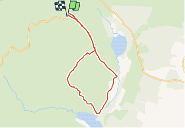

Length
13.1 km

Max alt
590 m

Uphill gradient
673 m
Km-Effort
22 km

Min alt
208 m

Downhill gradient
672 m
Boucle
Yes
Creation date :
2014-12-10 00:00:00.0
Updated on :
2014-12-10 00:00:00.0
--
Difficulty : Unknown

FREE GPS app for hiking
 SityTrail
IGN / Geographical institutes
SityTrail Plus
The world is yours!
About
Trail Walking of 13.1 km to be discovered at Unknown, County Wicklow, The Municipal District of Wicklow. This trail is proposed by jaf299.
Positioning
Country:
Ireland
Region :
Unknown
Department/Province :
County Wicklow
Municipality :
The Municipal District of Wicklow
Location:
Glendalough
Start:(Dec)
Start:(UTM)
680568 ; 5888750 (29U) N.
Comments